
KENTUCKY 11 MOTORCYCLE RIDE ROUTES
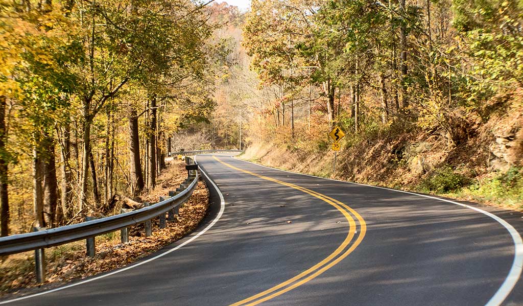
ROUTE 1 | RATTLESNAKE / DANIEL BOONE NATIONAL FOREST
100 miles
Click Here for Google Maps route
Click Here for H-D® Ride Planner route
This route goes through four counties and includes the legendary Rattlesnake. Route time is about two and a half hours.
DIRECTIONS:
- Left out of Wildcat Harley-Davidson® onto Hal Rogers Pkwy
- Left onto Heritage Rd
- Right onto KY-3432/W 16th St
- Right onto KY-192W
- Stay right on KY-192W
- Right onto State Hwy 1003
- Right onto Hal Rogers Pkwy/KY-80E
- Left onto KY-1956E
- Left onto KY-1249N/Sand Springs Rd
- Right onto US-25S/S Wilderness Rd
- Left onto S Upper River Rd
- Right onto KY-490/S Upper River Rd
- Left onto KY-578 E
- Right onto Mt Pleasant Rd
- Right onto KY-30 W
- Right onto Hal Rogers Pkwy
- Left into Wildcat Harley-Davidson®
ROUTE 2 | ROUTE OF PARKS
.png)
180 miles
Click Here for Google Maps route
Click Here for H-D Ride Planner route
This route goes through Cumberland Falls State Park, Pine Mountain State Park, and the Pinnacle Overlook at Cumberland Gap National Historic Park, with options to visit the Chained Rock Overlook on Pine Mountain. Plan for lots of curves and high-altitude climbs. Route time is about four and a half hours.
DIRECTIONS:
- LEG #1:
- Left out of Wildcat Harley-Davidson® onto Hal Rogers Pkwy
- Left onto Heritage Rd
- Right onto KY-3432/W 16th St
- Right onto KY-192W
- Bear left onto KY-1193 S
- Right onto Hwy 25 S
- Bear right onto KY-90 W
- Turn right into Cumberland Falls parking area
- LEG #2:
- Left out of parking area onto KY-90 E
- Continue onto Hwy 25 S
- Left onto KY-92 E
- Right onto US-25E Scenic S/Hwy 25 E S/US-25 E S
- Right onto State Hwy 190
- Bear right onto State Hwy 1491
- Bear right onto State Hwy 382
- Turn left into Pine Mountain parking area
- LEG #3:
- Right onto State Hwy 382
- Continue onto State Hwy 1491
- Bear left onto State Hwy 190
- Right onto US-25E Scenic S/Hwy 25 E S/US-25 E S
- Right onto exit toward US-25E S
- Right onto Pinnacle View Rd
- Left into Pinnacle Overlook parking area
- LEG #4:
- Left onto Pinnacle View Rd
- Ramp onto US-25E Scenic N/Hwy 25 E N/US-25 E N
- Right onto State Hwy 229
- Right onto KY-192 E
- Left onto Hal Rogers Pkwy
- Left into Wildcat Harley-Davidson®
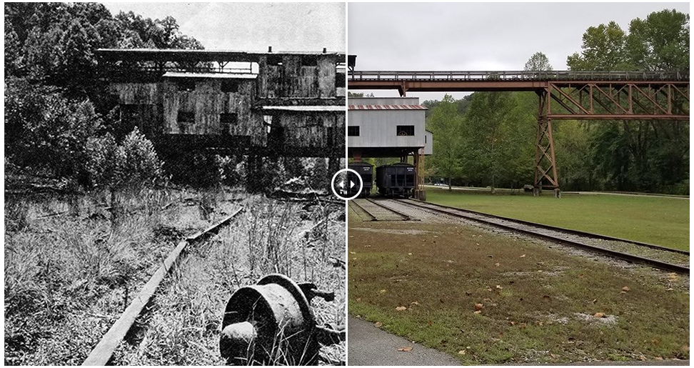
ROUTE 3 | BLUE HERON MINING COMMUNITY
172 miles
Click Here for Google Maps route
Click Here for H-D Ride Planner route
This route stops in Stearns, KY, at the site of the former Blue Heron Mining Community. The mine closed in 1962, and the area has since been recreated as an outdoor museum. Route time is about four and a half hours.
Click Here to learn more about Blue Heron Mining Community
DIRECTIONS:
- LEG #1:
- Left out of Wildcat Harley-Davidson® onto Hal Rogers Pkwy
- Left onto Heritage Rd
- Right onto KY-3432/W 16th St
- Right onto KY-192W
- Bear left onto KY-1193 S
- Right onto Hwy 25 S
- Bear right onto KY-90 W
- Left onto State Hwy 1045/State Hwy 700
- Left onto State Hwy 700
- Left onto Jennys Branch Rd
- Left onto US-27S
- Right onto KY-92 W
- Left onto State Hwy 1651
- Right onto KY-741
- Right onto State Hwy 742
- Continue onto Blue Heron Rd
- Left into Blue Heron Mining Community
- LEG #2:
- Blue Heron Rd onto State Hwy 742
- Left onto KY-741
- Left onto State Hwy 1651
- Left onto KY-92 W
- Right onto State Hwy 776
- Bear left onto KY-790 N
- Right onto KY-90 E
- Continue onto KY-1247 N
- Right onto KY-914 E
- Right onto KY-192 E
- Left onto State Hwy 1003
- Continue onto State Hwy 1675
- Right onto Sandy Gap Rd
- Right onto KY-80 E/W Hal Rogers Pkwy
- Right into Wildcat Harley-Davidson®
ROUTE 4 | KENTUCKY MIST

219 miles
Click Here for Google Maps route
Click Here for H-D Ride Planner route
A combination of open four-lane and twisty secondary roads to the Kentucky Mist Distillery in Whitesburg. Route time is about five hours.
Click Here for the Kentucky Mist Distillery website
DIRECTIONS:
- LEG #1:
- Right out of Wildcat Harley-Davidson® onto Hal Rogers Pkwy
- Right onto Exit 56 for KY-451 S
- Left onto KY-451C/KY-451 Connector
- Right onto Johnny Cox All-American Dr
- Bear right onto KY-15 S
- Right onto Depot St/Main St
- Right onto E Main St
- Continue onto Madison St
- Turn left into Kentucky Mist Distillery
- LEG #2:
- Right onto Madison St
- Left onto E Main St
- Left onto Depot St/Main St
- Right onto KY-15 S
- Right onto US-119 S
- Right onto US-421 N
- Left onto KY-80 W
- Right onto KY-192 E
- Left onto Hal Rogers Pkwy
- Left into Wildcat Harley-Davidson®
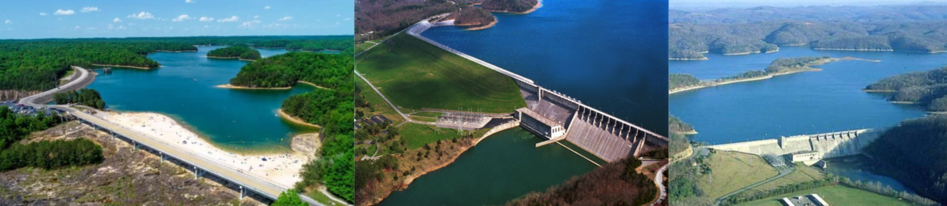
ROUTE 5 | BEST DAM RIDE AROUND
163 miles
Click Here for Google Maps route
Click Here for H-D Ride Planner route
This one-way route visits three dams in the area: Laurel River Dam, Wolf Creek Dam, and Dale Hollow Dam. The route enters the Central Time Zone and also crosses into Tennessee, so helmets will be required for a portion of the trip. Route options include visiting the Wolf Creek National Fish Hatchery, as well as considering an overnight stay at Dale Hollow Lake State Resort Park. Route time is about four hours.
Click Here for information about Wolf Creek National Fish Hatchery
Click Here to view lodging at Dale Hollow Lake State Resort Park
DIRECTIONS:
- LEG #1:
- Left out of Wildcat Harley-Davidson® onto Hal Rogers Pkwy
- Left onto Heritage Rd
- Right onto KY-3432/W 16th St
- Right onto KY-192W
- Bear left onto KY-1193 S
- Turn right into Laurel River Dam parking area
- LEG #2:
- Right onto KY-1193 S
- Right onto Hwy 25 S
- Bear right onto KY-90 W
- Left onto State Hwy 1045/State Hwy 700
- Left onto State Hwy 700
- Left onto Jennys Branch Rd
- Left onto US-27S
- Right onto KY-92 W
- Left onto Main St
- Continue onto KY-167 S/S Main St
- Right onto State Hwy 200
- Right onto State Hwy 858
- Left onto KY-90 W (entering Central Time Zone)
- Right onto US-127 N
- Left onto Dam Rd
- Turn right into Wolf Creek National Fish Hatchery
- LEG #3:
- Left onto Dam Rd
- Right onto US-127 S
- Right onto State Hwy 1590
- Right onto KY-90 W
- Left onto State Hwy 449
- Continue on State Hwy 449
- Left onto KY-61 S (entering Tennessee, which has helmet laws)
- Continue onto TN-53 S
- Left onto Dale Hollow Dam Rd
- Stay on Dale Hollow Dam Rd
- Turn right into Dale Hollow Dam parking area
ROUTE 6 | FOUR ROSES DISTILLERY

112 miles
Click Here for Google Maps route
Click Here for H-D Ride Planner route
This ride ends up in Lawrenceburg at the iconic Spanish Mission-style Four Roses Distillery, built in 1910 and listed on the National Register of Historic Places. Route time is about two and a half hours.
Click Here for the Four Roses Distillery website
DIRECTIONS:
- Left out of Wildcat Harley-Davidson® onto Hal Rogers Pkwy
- Right onto State Hwy 1317
- Right onto KY-39 N
- Left onto KY-39 N/Main St
- Bear right onto KY-39 N/State Hwy 39/Lancaster St
- Right onto US-27 N
- Left onto Bethel Rd/Greystone Dr
- Continue onto State Hwy 1268
- Right onto W Main St
- Continue onto State Hwy 1268/Jewell Rd
- Left onto US-68 W
- Right onto KY-33 N
- Left onto KY-9002 W/Bluegrass Pkwy
- Exit 59B onto US-127 N
- Left onto KY-513 W
- Right into Four Roses Distillery
ROUTE 7 | WOODFORD RESERVE DISTILLERY

103 miles
Click here for Google Maps route
Click here for H-D Ride Planner route
This route borrows some roads from the Four Roses ride, but with a different destination. You'll arrive in Versailles at the beautiful Woodford Reserve Distillery, which sits on Kentucky's oldest distilling site.
Click here for the Woodford Reserve Distillery website
DIRECTIONS:
- Left out of Wildcat Harley-Davidson® onto Hal Rogers Pkwy
- Right onto N Main St/Mt Vernon Rd
- Continue onto US-25 N/N Laurel Rd
- Continue onto US-150 W/Crab Orchard Rd
- Right onto KY-39 N
- Left onto KY-39 N/Main St
- Bear right onto KY-39 N/State Hwy 39/Lancaster St
- Right onto US-27 N
- Left onto Bethel Rd/Greystone Dr
- Continue onto State Hwy 1268
- Right onto W Main St
- Continue onto State Hwy 1268/Jewell Rd
- Left onto US-68 W
- Right onto KY-33 N
- Right onto KY-9002 E/Bluegrass Pkwy
- Exit 72B onto US-60 W
- Left onto US-60/Lexington Rd
- Right onto US-60W/Versailles Bypass
- Left onto Steele Rd
- Bear right onto KY-2331
- Right onto KY-1659 N
- Left into Woodford Reserve Distillery
ROUTE 8 | MINE PORTAL 31
.jpg)
228 miles
Click here for Google Maps routeClick here for H-D Ride Planner route
This ride through the Appalachian mountains takes you to historic Harlan County and the town of Lynch, which was built in 1917 and was the world's largest coal camp at that time. Portal No. 31 offers tours five days a week, as visitors get the unique experience of traveling through the mine in a rail car. Part of the return route goes through Virginia, so helmets will be required for a portion of the trip. Route time is about five and a half hours.
Click here for the Portal 31 website
DIRECTIONS:
- LEG #1:
- Right out of Wildcat Harley-Davidson® onto Hal Rogers Pkwy
- Right onto KY-118 E
- Left onto Main St
- Left onto KY-80 E
- Right onto KY-699/State Hwy 699
- Right onto State Hwy 463
- Continue onto KY-160 S
- Bear left onto KY-160 S/State Hwy 522
- Left onto Church St/Cs-5001
- Left into Portal 31
- LEG #2:
- Right onto Church St/Cs-5001
- Left onto KY-160 S/W Main St
- Continue onto VA-160 E/N Inman St (entering Virginia, which has helmet laws)
- Left onto N Inman St
- Right onto US-23 BUS S/W Main St
- Right onto Wood Ave E
- Continue onto US-58 ALT W/Cumberland Ave W
- Right on US-421 N (entering Kentucky)
- Left onto US-119 S
- Right onto US-25E Scenic N/Hwy 25 E N/US-25 E N
- Continue onto US-25E Scenic N/Hwy 25 E N/ Cumberland Gap Pkwy/US-25 E N
- Right onto State Hwy 229
- Right onto KY-192 E
- Left onto Hal Rogers Pkwy
- Left into Wildcat Harley-Davidson®
ROUTE 9 | SGT. YORK STATE HISTORIC PARK

217 miles
Click here for Google Maps routeClick here for H-D Ride Planner route
This ride takes you across the southern Kentucky border into Pall Mall, Tennessee, to the home of World War I hero Sgt. Alvin C. York, one of the most celebrated soldiers in American history. Available for tours, and listed on the U.S. National Registry of Historic Places, the grounds include a house, church, mill, post office, cemetery, and more. The route enters the Central Time Zone and also crosses into Tennessee, so helmets will be required for a portion of the trip. Route time is about five and a half hours.
Click here for State Park information
Click here for the Sgt. York Patriotic Foundation site
DIRECTIONS:
- LEG #1:
- Left out of Wildcat Harley-Davidson® onto Hal Rogers Pkwy
- Left onto Heritage Rd
- Right onto KY-3432/W 16th St
- Right onto KY-192W
- Bear left onto KY-1193 S
- Right onto Hwy 25 S
- Bear right onto KY-90 W
- Left onto State Hwy 1045/State Hwy 700
- Left onto State Hwy 700
- Left onto US-27 S
- Right onto KY-92 W
- Left onto State Hwy 1756
- Left onto KY-167 S (entering Tennessee, which has helmet laws)
- Continue onto TN-154 S (entering Central Time Zone)
- Left toward US-127 BYP N
- Right onto US-127 BYP N
- Continue onto US-127 N
- Right at Reed Creek Rd into Sgt. Alvin C. York State Historic Park
- LEG #2:
- Right onto US-127 N (entering Kentucky)
- Right onto State Hwy 1076
- Right onto State Hwy 696
- Left onto State Hwy 415/State Hwy 696
- Right onto State Hwy 696
- Continue onto Duvall Valley Rd
- Continue onto State Hwy 696
- Left onto State Hwy 1009 (entering Eastern Time Zone)
- Right onto KY-90 E
- Continue onto KY-1247 N
- Right onto KY-914 E
- Right onto KY-192 E
- Left onto KY-3432
- Left onto Heritage Rd
- Right onto W Hal Rogers Pkwy
- Right into Wildcat Harley-Davidson®
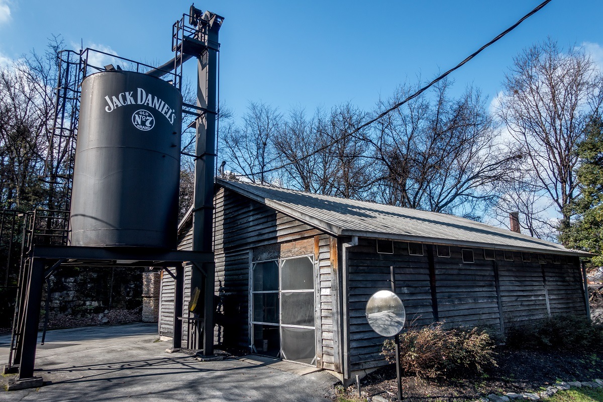
ROUTE 10 | JACK DANIEL'S DISTILLERY
246 miles
Click here for Google Maps routeClick here for H-D Ride Planner route
It's not bourbon, but we made an exception for this route, which ends in Lynchburg, Tennessee, at the historic Jack Daniel's Tennessee Whiskey Distillery. The route enters the Central Time Zone and also crosses into Tennessee, so helmets will be required for a portion of the trip. Route time is about five and a half hours.
Click here for the Jack Daniel's Distillery website
DIRECTIONS:
- Left out of Wildcat Harley-Davidson® onto Hal Rogers Pkwy
- Left onto KY-914 W
- Merge onto Cumberland Pkwy
- Exit 78 for KY-80 toward Nancy
- Right onto KY-80 W (entering Central Time Zone)
- Left onto US-127 S
- Continue onto US-127 S (entering Tennessee, which has helmet laws)
- Continue onto TN-111
- Right onto Bradford Hicks Dr
- Right onto TN-111 S/W Main St
- Left onto US 70S W ramp to McMinnville
- Continue onto US-70S W
- Left onto Bobby Ray Memorial Pkwy/H T Pelham Memorial Pkwy
- Continue onto TN-55 W
- Right onto S Jackson St
- Left onto TN-55 W/Wilson Ave
- Left into Jack Daniel's Distillery Visitor Center
ROUTE 11 | NATURAL BRIDGE / RED RIVER GORGE / SKY BRIDGE

148 miles
Click here for Google Maps routeClick here for H-D Ride Planner route
This roundtrip ride goes northeast into the Daniel Boone National Forest and offers a spectacular view of some of nature's most beautiful creations. The first stop is Natural Bridge State Resort Park, where visitors can take a skylift up to the Natural Bridge sandstone arch. Afterward, pass through the Nada Tunnel and Red River Gorge before arriving at the Gladie Visitor Center, in the heart of the Gorge. The next stop is a quick ride over to the Sky Bridge, another sandstone arch that sits nestled in the Gorge. Route time is about three and a half hours.
Click here for information about Natural Bridge State Resort Park
Click here for information about Red River Gorge
DIRECTIONS:
- LEG #1:
- Right out of Wildcat Harley-Davidson® onto Hal Rogers Pkwy
- Left onto KY-30 E
- Left onto US-421 N
- Right onto State Hwy 1431
- Left onto State Hwy 1431/State Hwy 1709
- Right onto Big Barn Rd/Cr-1154-20/Herd-Elias Rd
- Right onto KY-30 E
- Continue onto KY-11 N
- Left onto KY-11 N/Broadway
- Left onto Middle Fork Campground Rd E
- Right into Natural Bridge parking area
- LEG #2:
- Left onto Middle Fork Campground Rd E
- Left onto KY-11 N
- Left onto KY-11 N/KY-15 N
- Right onto KY-77 N (route passes through Nada Tunnel)
- Right onto KY-715 S
- Right into Gladie Visitor Center
- LEG #3:
- Right onto KY-715 S
- Right onto Sky Bridge Rd
- Arrive at Sky Bridge parking area
- LEG #4:
- South on Sky Bridge Rd
- Right onto KY-715 S
- Left onto KY-11 S
- Continue onto KY-30 W
- Left onto Big Bard Rd/Herd-Elias Rd
- Left onto State Hwy 1431/State Hwy 1709
- Right onto State Hwy 1431
- Left onto US-421 S
- Right onto KY-30
- Right onto Hal Rogers Pkwy
- Left into Wildcat Harley-Davidson®